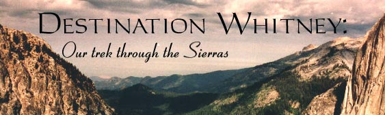
This trip began several years before it took place, six in fact. On my tenth birthday my father suggested that we take a backpacking trip together, that we climb Mt. Whitney, and that we fund it by recycling aluminum cans. It sounded great at the time, so we began our project. Six years, one severe round of doubts, which ended as I got older, many pounds of cans (about $300 worth) later, the trip was a reality. We collected enough cans to finance the trip, or most of it. However, much of that money had become IOU notes in a collection box. It didn't matter. We planned our meals, packed our bags and headed out to Sequoia National Park and Crescent Meadow, our departure site. We spent a night in Sequoia, a gorgeous park, I'd recommend it to anyone, and early the next morning drove to Crescent Meadow, strapped on our packs and started out.
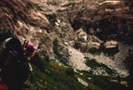
This was my first serious backpacking trip, and although I'd like to claim that years of school sports and summer league volleyball had left me in shape, the first day hurt. I needed a break not long in, so we stopped and Dad braided my pony-tail. What else do you do with hair that falls to the middle of your back? We moved on. I tried to keep my complaining to a minimum, but I was not particularly fond of the mouth clogging dirt on the trail. I wanted granite (which was somewhat visible through the trees, but not entirely). Finally, late in the afternoon we made it to our first night's stop, 6 miles in, and some good number of feet up. It was a small creek flowing down over rocks; a good place to stop as evidenced by the number of people there. I was incredibly happy to drop the 45 lbs., more than I'd every carried, off my back. The campfire conversation was fun, and the peach that came after dinner was the best I've ever had. Hiking does that.
The next morning was almost more painful than the end of the day
before. I don't think I've ever had such bruises on my hips as I did from
that pack. The towel wrapped around my waist helped to some extent, but
not enough to make me happy, or keep me from grumbling. Of all the days,
that second one was probably the hardest. Up and down through beautiful
woods, which I mostly did not pay enough attention to to appreciate, and
the dust they left, which I noticed entirely too much. A respite was
found at an icy creek just below a long hike up. (Feet love cold water).
And lunch was had at the top of that climb: Bearpaw Meadow. It isn't much
of a meadow, more of a camp outpost, but it's got a great view.
Continuing on after lunch was even harder than leaving that morning, but
it happened, not without many remarks from me. (I wasn't in the best of
moods that day). But, not too long after that, we broke through the tree
line.
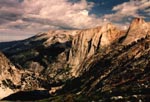
 Suddenly we were hiking on the edge of the world, a granite path with a
dive down to the valley below, the Castle Rocks and Valhalla towering
across the valley to our right and up ahead of us, like some Norse God's
castles. I think I got my addiction to granite right then. We stopped
for a while at another creek to cool our feet and then continued on, up in
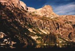
this case, toward the Hamilton Lakes, our second night's destination.
Nearing the end of that hike, Dad headed on before me, needing to finish,
and I trailed behind, making my painful way up, pausing to cool my feet at
the top of a waterfall, allaying my pain with Jolley Ranchers and finally
topping the rise to the second of the two lakes to see this. Putting down
my backpack and sitting on the granite beside the lake was glorious.
Suddenly we were hiking on the edge of the world, a granite path with a
dive down to the valley below, the Castle Rocks and Valhalla towering
across the valley to our right and up ahead of us, like some Norse God's
castles. I think I got my addiction to granite right then. We stopped
for a while at another creek to cool our feet and then continued on, up in
this case, toward the Hamilton Lakes, our second night's destination.
Nearing the end of that hike, Dad headed on before me, needing to finish,
and I trailed behind, making my painful way up, pausing to cool my feet at
the top of a waterfall, allaying my pain with Jolley Ranchers and finally
topping the rise to the second of the two lakes to see this. Putting down
my backpack and sitting on the granite beside the lake was glorious.
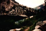
We tooke the next day off and stayed at Upper Hamilton Lake, letting our bodies adjuts to the altitude, stretching out sore muscles and letting bruises heal. I clambered over boulders around the lake, intrigued by a waterfall on the far side. I made it to the first real fall, but couldnt' climb any higher. Dad spent his time mostly fishing, and we both washed our clothes.A boyscout troop joined us there in the afternoon of the second day, and in the evening, a couple made it into camp, looked for a place to put their bed rolls and ended up sharing our campfire. That day of pure relaxation was nearly idyllic.
 After our day's haitus (sp) we set out again, our
destination Nine Lakes Basin, over a ridge at the top of the rock
walls surrounding us. We had looked at the map, we had heard rumors: it
was a killer four hour hike up the steep valley walls. And it lead us
past Precipice Lake. For any Ansel Adams fans out there, Precipice
Lake is one of the ones he has photographed. It always struck me as
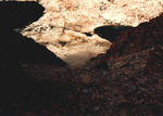
desolate, but once there, I was amazed. But that's later.
After our day's haitus (sp) we set out again, our
destination Nine Lakes Basin, over a ridge at the top of the rock
walls surrounding us. We had looked at the map, we had heard rumors: it
was a killer four hour hike up the steep valley walls. And it lead us
past Precipice Lake. For any Ansel Adams fans out there, Precipice
Lake is one of the ones he has photographed. It always struck me as
desolate, but once there, I was amazed. But that's later.
We started up the trail with lighter packs and much higher spirits for our day layover. Looking back, this is what we saw: our camping spot in the distance, across the water, and beyond that the Sequoia Valley. In front of us, one of the waterfalls we had seen when we first arrived hovered on our level, but we were not even halfway up the walls. I lead most of the way up that hike, and was reminded of a motto I had developed two days before as we went down an incline we had laboriously truged up moments before: "No backtracking allowed,"
I also developed "No pain, no fear, no end, no sanity" near the beginning as the walls reached endlessly up. I was amazed when we neared the top of our climb. It hadn't been as long as I expected, or as painful, probably due to many water stops. This is what we saw at one of those breaks. There's something incredible about standing on a crushed granite face, sparcely covered with blooming wild flowers, and seeing the world below and behind you, and storm clouds gathering and raining on the valley you've just hiked out of. You feel somewhere in between the smallest ant, some kind of god, and a bird. I've always wanted to fly, and until I learn to sky dive, looking down into that valley will probably be as close as I ever get.
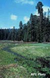
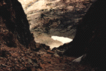
As stunning as the view back into the Sequoia valley was, what lay just over the top of the granite walls was in some ways even more incredible. I've long loved lakes, and I've long been an Ansel Adams fan, but seeing this one in person was just something a little different. Precipice Lake, lying in a small boulder strewn cup below Eagle Scout Peak and high above the Hamilton lakes is truly incredible.
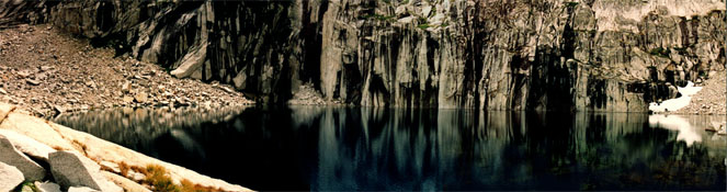
I've never seen anything quite as flat as that lake, or water so cold that looking at it you think the cold is what makes the water get darker as it gets deeper.
The storm coulds behind in the valley caught up to us while we were there. That was the first rain of the trip. It was a lovely afternoon thundershower that lasted only long enough to make our ponchos worth while. The sun came out soon after and dad wandered around the lake while I had a relaxing lunch, sitting on my little promotory, staring at the water, the clouds, the mountain of granite and its reflection. It was almost surreal...the colors in the water went through most of the rainbow before they faded to black and were replaced by reflections.
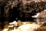
The couple who had joined us down at Hamilton lake our second night caught up with us at Precipice Lake, and we all headed up the path over and out the Kawea Gap together. We paused at the top, sheltering from the wind under a boulder, long enough to look at maps, see that our paths parted ways wish each other luck. Dad and I were going cross country the next day, and we were headed to the uppermost of the 9 Lakes, while they followed the trail down the valley.
Dad and I passed the boyscouts from Hamilton lake, who were camping at the second highest lake, and made our way across sparce grass and rock that made me think of Scotland (although I've never been there). We created a small shelter behind a rock with our tarp over us as the clouds continued to look threatening. It was cold and windy, and even in thermals and windbreaking gear I was damp and cold. That was probably my most miserable afternoon and evening. It didn't help that we had looked at a map and found our next day's hike, up. Up a shale cut in the mountains called Pants Pass. It loomed over me as I stayed in my sleeping bag reading Grisham's The Pelican Brief while dad wandered the valley. The soup we had for dinner (Knorr Ox Tale) was the best soup I'd ever had, just by virtue of being warm. I do have to admit that while I was miserable, the sunset was quite beautiful. The alpine glow off the Kawea Mountains was truely incredible. Pinks and oranges that shouldn't exist in granite.
The next morning we headed around the small puddle of a brown lake that we had camped by and across the boulder and shale strewn mountain feet to the waterfall of shale that was Pants Pass. I learned the reason for the name quickly as I slithered and pulled and tried to climb my way up it. The tallus slop was probably at a 60 degree angle, making every step of progess only a half step. Breaks were necessary, but not easy to come by, since you had to hold onto or prop yourself up against a rock in order to avoid slipping down and loosing precious height.
It was a pretty rough climb, and the view from the top, while extrodinary, was not exactly comforting. When I walked the 12 feet from the top of the left side to the descent on the right, I believe I actually said, "I'm not going down that." It was steeper going down than coming up, and what was worse, you couldn't see the slope all the way to the bottom. I kept imaging sliding down through the tallus and right over the edge of an unseen cliff several hundred feet tall. It took me a while of sitting and thinking to get my mind around the idea of going down. I did eventually, but I wasn't happy about it. Until I started going down.
Then I discovered a new sport: Rock Surfing.
Rock surfing is an interesting sport, requiring heavy soled leather boots and good balance. Gloves are probably advisable, as are, of course, pants, since tallus slopes do tend to toss rocks up as you surf down them. As the inventor, I also discovered that the backpack can be both a burden and a boon. The weight of the pack pulls at your shoulders and makes turning somewhat challenging, however, it does ensure that overbalancing and falling forward is less likely. If you slip on a quick turn, you end up with the pack cushioning your fall. Proper technique for rock surfing is relatively simple: your leading (downhill) leg should be fully extended, guiding the direction of your surf. Your trailing (uphill) leg should be bent to at least an 80 degree angle at the knee, and can be as bent as 120, depending on the slope you are surfing. Your arms should be outspread for balance, and style. (You earn extra points for singing Beach Boys songs or doing "The Swim" while surfing.) I suggest slopes of at least 60 degrees, as your backwards fall will be minimalized, and it is easier to regain a standing position if one should fall. I myself have only had experience with the eastern (I think) face of Pants Pass, so I am not an expert on the variations possible in rock surfing.